
Press Release
Trail Mountain Fire Morning Update
Sunday, June 16, 2018
Start Date: June 4, 2018 Size: 13,710 acres
Percent Contained: 17%
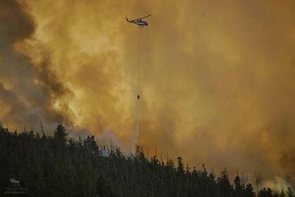
Helicopters: 8 Engines: 23
Crews: 15 Total Personnel: 598
Summary: Emery County Sheriff’s Office reopened Highway 31 through Huntington Canyon at 7 a.m. Firefighters and equipment will still be working along the highway, and smoke could reduce visibility at times. Drivers should use caution in this area.
Cloud cover and higher relative humidity limited fire activity yesterday and will do the same this morning. Overnight clouds prevented aerial mapping of the fire to get updated acreage; however, there was no significant growth of the fire yesterday. This afternoon drier conditions and clearing skies will return. Winds will increase from the south. Tomorrow, temperatures will return to normal.
The majority of the southern perimeter of the fire has been contained. Much of the east and west sides of the fire have fireline in place, and fire managers have used and continue to use small burnouts to reduce vegetation between the fire boundary and the fireline. Additionally, crews have been able to build some fireline directly along the active fire. Crews have been successful to date in meeting one of the primary objectives of the incident – keeping the fire west of Highway 31.
To the north of the fire, a wide range of vegetation types exists including conifers, bug-killed trees, aspens, pinyon, and juniper. This vegetation has been responding to fire in very different ways. Fire managers continue to evaluate the interaction between weather, terrain, and vegetation to design and implement the best strategy for containing this fire to the north. Also in this area, firefighters have reduced vegetation and installed sprinklers around the Crandall Canyon Mine Memorial.
Closures: The Manti-La Sal National Forest has an area closure in effect around the fire. See a map and description of the area at: https://inciweb.nwcg.gov/incident/maps/5830/. Horse Canyon Trailhead, Indian Creek Campground, Little Bear Campground, Lower Little Bear Campground and Riverside Campsite are closed. Highway 31 is open as of 7 a.m.
For More Information: Visit InciWeb at https://inciweb.nwcg.gov/incident/5830/ and Utah Fire Info at https://utahfireinfobox.com/. You can also follow Utah Fire Info on Twitter, https://twitter.com/UtahWildfire, and Facebook, https://www.facebook.com/UtahWildfire/.