
В
Fire Information
Date started: Tuesday, 6/26/2012 5:30 a.m.
Number of personnel: 638 national resources
Location: 15 miles NW of Huntington, Utah
Equipment: 21 engines from all over the country
Cause: Dry Lightning
Aircraft: 8 helicopters
Size: 48,449 acres, (76 square miles)
Hand Crews: 14 (20-person each)
Percent contained: 21%
Dozers: 2
Projected Spread: North and West
Water Tenders: 14
Management Strategy: Full Suppression
Estimated containment date: 7/15/2012
Injuries to date: none
Cost to date: $4,602,505
Weather Forecast: A moist trough of low pressure remains over the area continuing to bring an increased chance of erratic winds and possible dry lightning. High pressure ridge to redevelop by the weekend.
Property threatened: Several evacuated communities, 250 residences, 15 commercial properties, 500 outbuildings, recreation facilities, communication towers, utility lines, gas lines, coal mining facilities.
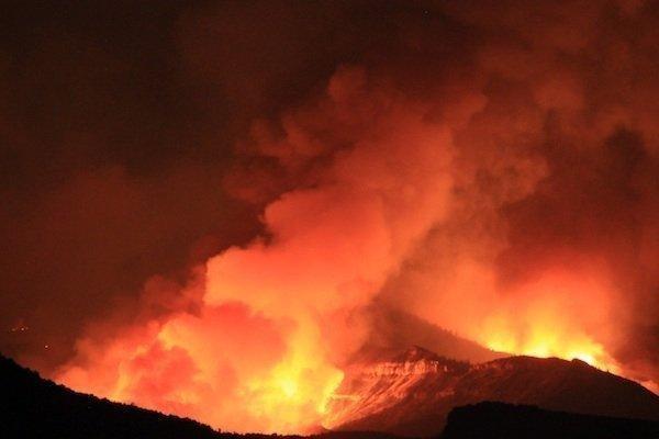
Thursday’s Fire Activity: 0.4 to 0.6 inch of precipitation was received over the fire which slowed burnout operations on the west and north fire perimeters. Seeley Mountain on the southwest side showed little smoke as fuels have mostly burned out, coupled with the rain. A handcrew continued direct attack working on a section of fireline on the west side of the fire near Candland Mountain. Burnout operations, to protect structures, between Coal Canyon and Cox Canyon near Electric Lake were successful near the northwest perimeter. Overnight winds on Wednesday pushed the fire north but the movement was checked in Snyder Canyon. A spot fire in Magazine Canyon is being monitored. The main fire remains south of the community of Clear Creek. The burnout operation initiated on Wednesday established a solid blackline at the north perimeter along the pipeline easement. Crews worked late on the burnout until fuels became too moist to burn. Due to the rain, fuels became less burnable on the east side of the burnout and crews were able to go direct and finish the line. Crews were also able to increase containment between Second Water and Bob Wright Canyons. There was little to no fire activity along the fire’s east to southeast perimeter. Firefighters worked near Gentry Mountain and finished constructing direct line on the south perimeter. Fire continues to back down through a small stand of dead spruce close to State Route 31.
Today: Weather conditions permitting, burnout operations will continue to be executed from the northwest to northeast corner of the fire. Residents may see smoke over Huntington Creek, Castle Valley and Bob Wright Canyon. Handcrews will continue to improve existing and build additional fireline near Candland Mountain. Crews plan additional work on containment lines in Bob Wright Canyon and around the stand of dead burning spruce close to State Route 31. Crews will continue with mop-up and patrol along the east, southern, and southwest perimeter of the fire. Structure protection remains in place if needed.
Closures/Evacuations/Advisories: Road closures include: SR-31 at Crandall Canyon and at Miller Flat, FS-014 from Miller Flat Road south to Potters Flat, SR-122 at junction of SR-10, SR-139W at the railroad tracks, SR-96 and SR-6. SR-264 at Flat Canyon Reservoir. Evacuation areas include: Electric Lake, Scofield, Clear Creek, Cleveland campground, Miller Flat Reservoir and Hog Flat areas, and several youth camps. Hiawatha has been re-opened to residents only. Access to a coal load out facility at Wattis was also reopened. Carbon County Sheriff’s office is coordinating permitted escorted visits into evacuation areas for immediate needs. Please call 435-636-3746 to request an appointment with an officer.
В
В
В