
В
The Seeley Fire began on the Manti-LaSal National Forest with a lightning strike on June 26 and was reported at about 6 a.m. that day.
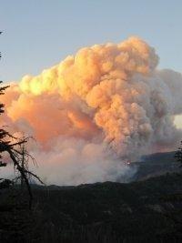
The fire gained intensity as it entered areas containing large components of decadent standing beetle-killed timber, dead and down fuels. Area residents and visitors saw large columns of smoke for several days.
Friday’s Fire Activity:
Fire activity slowed with the moderated weather along the southwest, west, east and southeast perimeters of the fire.В Crews continued to patrol and mop-up in these areas. Crews improved and completed a piece of direct containment line on the west side of the fire near Candland Mountain. Debris from South Hughes Canyon slid down and blockedВ SR-31. Department of Transportation officials were notified. Crews mopped up the fire edge near residences in theВ northwest perimeter of the fire and used direct attack to secure fireline in Clear Creek. The main fire remains southВ of the community of Clear Creek. Fireline at the north perimeter of the fire along the pipeline easement held. CrewsВ used direct attack on several other portions of the northern fire perimeter. Containment line throughout the southeastВ perimeter of the fire was completed. Heat is being held in the top of Vicks Canyon presenting control challenges inВ combination with the heavy down and dead fuels locations.
A ridge of high pressure pushed moisture across Utah and the Seeley Fire on Thursday. The widespread wetting rain dropped 0.15 to 0.3 inches of rain on the fire.В Fire activity has since slowed, allowing firefighters safer opportunities to use direct attack tactics to construct fireline. As the weather returns to a warmer and drier pattern, fire activity is expected to increase again.
As containment line is achieved, formerly evacuated areas are being repopulated. The community of Hiawatha has been reopened to full-time residents. Scofield has been reopened and road closures are moving closer to the fire area allowing some rural property owners to return to summer cabins or vacation homes. The main fire remains 1 1/2 miles south of the historic community of Clear Creek. Heat is being held in the top of Vicks Canyon presenting control challenges in combination with the heavy down and dead fuels located in several spots along the fire perimeter.
Forest crews today will begin felling fire damaged trees in Huntington Canyon along SR-31 that present a hazard to the traveling public. SR-31, an important local travel route, has been heavily impacted by the fire and debris slides from South Hughes Canyon. Department of Transportation officials have been notified.
This area is summer mule deer range along with elk, goshawk habitat and several blue ribbon fisheries. Whirling disease and spread of whirling disease is of major concern.
Basic Information
Incident Type: Wildfire
Cause: Lightning
Date of Origin: Tuesday June 26th, 2012 approx. 05:30 AM
Location: 15 miles NW of Huntington, UT
Incident Commander: John Philbin, E. Arizona
Total Personnel: 647
Size: 48,397 acres
Percent Contained: 38%
Estimated Containment Date: Sunday July 15th, 2012 approx. 12:00 AM
Fuels Involved: 10 Timber (litter and understory), Timber, downed and dead fuels, beetle-killed timber, some sage and Pinon/Juniper.
Fire Behavior:В Smoking stumps and logs. Creeping and smoldering.
Significant Events:
Due to moderated fire behavior, firefighters were able to use direct tactics on the northwest side of the fire. Structure group continued to prep buildings. East and southeast sides of the fire continued cold trail and hot spots. Southern perimeter is being monitored from the air.
Planned Actions :
Southwestern area continue providing protection of mine, scout and construct potential control lines to hold fire edge in Section 24. Continue direct tactics. Monitor fire activity on southern and western sides. Northwest to northeast perimeters, continue direct tactics and monitor fire activity, implement backfire operations as conditions allow. Eastern side, cold trail and hot spots. Structure group continues triage and prepare structure protection plan for Gooseberry. Set up structure protection equipment. Provide support to burnouts on northwest side, as needed. Aerial ignition might be occuring. Night shift monitors and provides structure protection as needed.
Growth Potential:В High
Terrain Difficulty:В High
Remarks
Evacuations include the Electric Lake area, Clear Creek, Miller Flat Reservoir area, Hog Flat area and two youth camps. Due to the vicinity of the fire, a major oil and gas field has been shut down. Several working coal mines in the area remain under a pre evacuation notice. Land ownership: BLM 2186 acres, Private: 6023 acres, State 9581 acres and USFS 38324 acres, for a total of 48397 acres.
В