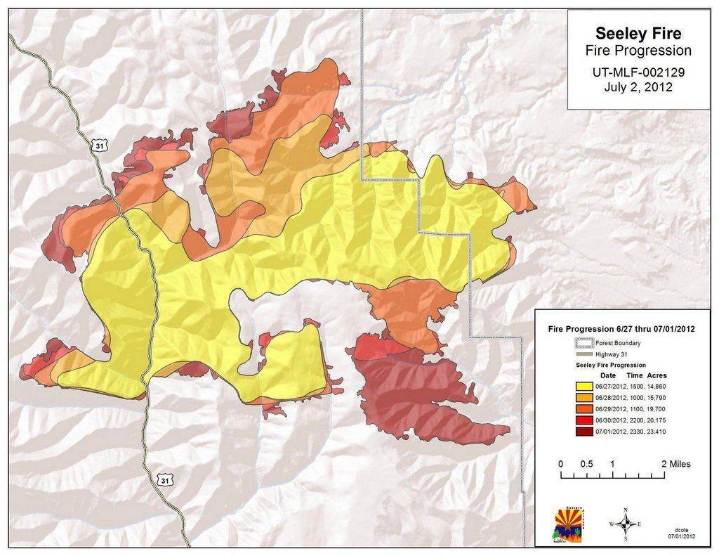
Seeley Fire Update
Fire Facts
Date started: Tuesday, 6/26/2012 5:30 a.m.
Number of personnel: 539 national resources
Location: 15 miles NW of Huntington, Utah
Equipment: 22 engines
Cause: Dry Lightning
Aircraft: 8 helicopters
Size: 33,410 acres
Hand Crews: 11 (20-person each)
Percent contained: 15 %
Water Tenders: 14
Management Strategy: Full Suppression
Dozers: 2
Projected spread: north and northeast
Estimated containment date: none
Injuries to date: none
Cost to date: $2,494,984
Complexity of Incident: John Philbin’s Eastern Arizona Type-2 Interagency Incident Management Team
Property threatened: Several evacuated communities, 250 residences, 15 commercial properties, 500 outbuildings, recreation facilities, guard stations, communication towers, utility lines, gas lines, coal mining facilities. Structure protection crews are in place. No structures have been lost on this fire.
Monday’s Fire Activity: Seeley Ridge is still holding on the southwest perimeter. Burnout operations using aerial ignition were completed on the western edge of the fire to halt the westward movement and eliminate spotting. The fire continued to burn west and north in the Mill Canyon and Flood Canyon area as a backing fire. On the northwestern flank in the Engineer Canyon area, fire continued to move slowly on shorter slopes, a terrain feature that helps moderate fire behavior. Fire continued to burn in Bob Wright Canyon, where firefighters completed a burnout operation using aerial ignition to encourage the moderate backing fire, mitigating the probability of spot fires in this area. Burnouts along the Trough Springs northern edge of the division took fire to the 48 road eliminating problematic fuels in the area. No new fire activity in the northeast Star Point area. Firefighters halted the southern movement just above the King Mine and the Left Fork of Miller Creek. No activity in the Wild Cattle/Gentry area. Several small smoke columns developed in the afternoon over various places on the fire. Firefighters held the line at a ridge northwest of Hiawatha and the fire did not get into Hiawatha. Firefighters were able to knock down the activity in Middle Fork Canyon and complete structure protection (including installing sprinklers in some areas) in Hiawatha, Clear Creek and Valentine. The town of Price continues to be heavily impacted by smoke blown east over town. Night shift crews continue structure protection for the evacuated areas.
Today: Weather will continue to be critically hot, dry and windy, with a probability of dry thunderstorms. Shifting wind patterns will carry fire in all directions, burning a lot of dry, dead, down bug-killed timber, which will continue to create a lot of smoke, rising into plumes beginning in the early afternoon.
Closures/Evacuations/Advisories: Road closures include: The road from SR-31 south through Millers Flat is closed to Potters Pond. Road is open from Potters Pond to Joe’s Valley, but camping is discouraged. SR-31 closed at Cleveland Reservoir and at Crandall Canyon. SR-264 closed at Electric Lake. SR-96 closed at SR-6. Fish Creek and Bear Ridge Roads closed at Scofield. Evacuation areas include: Electric Lake, Scofield, Clear Creek, Hiawatha, Cleveland, Miller Flat, Hog Flat, and several youth camps. Emery County Community Fire Information Meeting will be held at 6:00 p.m. tonight at the Emery High School Spartan Center located at 1000 N. Center, in Castle Dale, Utah.
В

