
Press Release
Rocky Mountain Incident Management Team- Dan Dallas, Incident Commander
Information Center: 385-448-0929
Hours of operation: 7 a.m. – 9 p.m.
Website: https://inciweb.nwcg.gov/incident/6101
Email: 2018_utmlf_coalhollowfire@firenet.gov
August 16, 2018, 8 a.m.
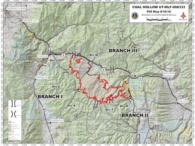
Current Situation: Fire behavior was moderated yesterday due to lighter fuels and increased cloud cover, helping to bring the total containment up to 16%. This increased containment has allowed the mandatory evacuation status for Zone 13 to be lifted to a pre-evacuation status. Diamond Fork Road remains closed.
Firefighters took advantage of calmer weather conditions in the early afternoon to conduct a successful firing operation in Division M and Q near US Highway 6. Today, work continues along Starvation Road as firefighters build additional containment line towards the Mill Fork Road.
On Division J, in the northwest fire area, hotshot crews were successful in improving the line from US Highway 6 to the ridge and constructing line to tie in at Lake Fork Road. Today, crews will continue to improve handline so additional firing operations can be conducted in this area.
On the north side of the fire along Highway 6 in Division R, objectives will include focusing on improving yesterday’s line up to the break with Division T. This afternoon, crews will begin a firing operation in this area, further strengthening the line and reducing available fuels.
On the southern half of the fire in Division T, X and Z, minimal growth was reported and crews will continue scouting the edge to determine the best location for additional indirect line, utilizing existing roads where possible. Structure protection has been conducted on surrounding areas since the fire began. These crews will continue to assess the structures around Skyline Road and Bennion Camp, implementing additional line and hose lays where necessary.
Weather: The chance of thunderstorms will continue through the day today with outflow wind gusts to 40 MPH possible. The slow movement of any thunderstorm that move over the fire will increase the potential of debris flows. The continued increase in moisture will lead to a higher relative humidity in the afternoon. Less cloud cover will allow inversions to break earlier than Wednesday.
Information Briefing: Daily public information briefings will be held at the info board at the Fairview Chevron, located at the Junction of Highway 31 and Highway 89 at 4 p.m.
Closures and Public Safety: The evacuation order for Zone 13 has been lifted from mandatory to pre-evacuation status, however, all Forest Service Closures remain in effect. Highway 6 closure has been lifted; however, the speed limit is reduced to 45 MPH. Closure orders can be found on national forest websites at https://www.fs.usda.gov/mantilasal/ and https://www.fs.usda.gov/alerts/uwcnf/alerts-notices.
Fire Statistics
Location: 15 miles southeast of Spanish Fork, UT
Start Date: Aug. 4, 2018
Size: 26,380 acres
Total Personnel: 729
Cause: Lightning
Percent Contained: 16%
Resources Include: 5 Type 1 hand crews, 9 Type 2 hand crews, 39 engines, 4 dozers, 11 water tenders, 7 helicopters, 2 fixed wing air tankers, 2 CL-415 Scoopers, 2 air attack platforms, 2 masticators and overhead/support personnel
Coal Hollow Fire Information
385-448-0929
2018_utmlf_CoalHollowFire@firenet.gov
https://inciweb.nwcg.gov/incident/6101/