Forest Service Press Release
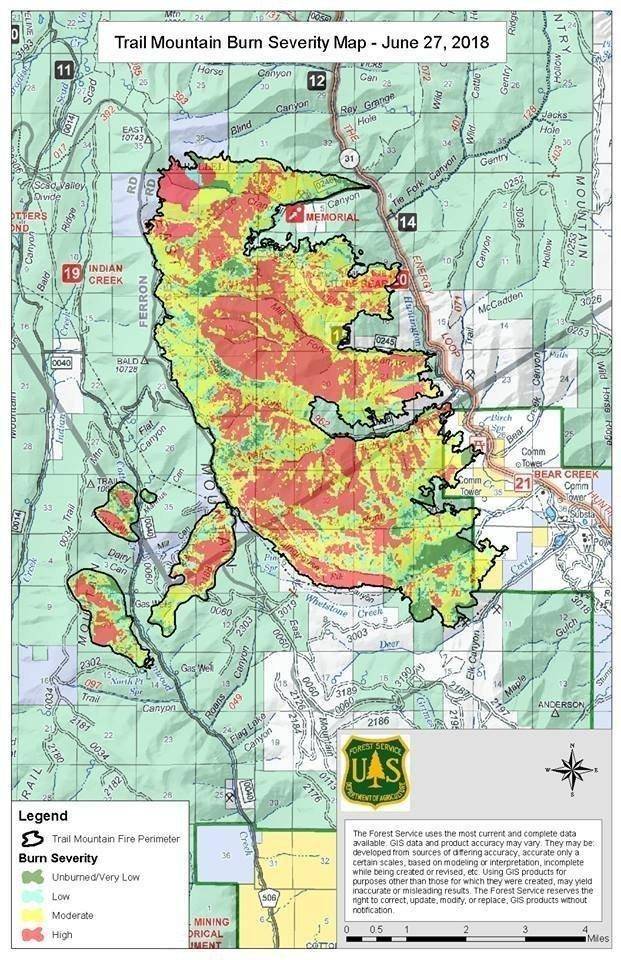
Burned Area Emergency Response (BAER) specialists recently completed their data gathering and verification field work of the Trail Mountain Fire burn area. The soil burn severity map has been finalized. soil burn severity levels are unburned, low, moderate and high.
The map shows that in the 17,694 acres analyzed by the BAER team within the Trail Mountain Fire area is either unburned (8%) or low (14%) soil burn severity, while 40% sustained a moderate soil burn severity, and 38% burned at high soil burn severity.
The BAER post-fire assessment team uses the soil burn severity data to identify if there are areas of concern where increased soil erosion, accelerated surface water run-off, and debris flows have the potential to impact human life/safety, property, and critical natural and cultural resources from storm events. The BAER team consists of Forest Service scientists and specialists that are considering emergency stabilization options for those critical resources.
BAER Team Leader Brendan Waterman said, “The BAER team expects erosion and run-off within the Trail Mountain Fire area to increase as a result of the fire because 78% of the burned area experienced moderate or high soil burn severity.” In specific areas that experienced moderate to high soil burn severity, there could be concern for run-off from steep hillslopes and resultant increases in post-fire soil erosion and debris flows.
The Trail Mountain Fire soil burn severity BAER map can be downloaded at the interagency “Trail Mountain Post-fire BAER” InciWeb site) as a JPEG or PDF version under the “maps” tab.
A “Field Guide for Mapping Post-Fire Soil Burn Severity” can help with interpreting the map and can be found online at https://www.fs.fed.us/rm/pubs/rmrs_gtr243.pdf.
SPECIAL NOTE: Everyone near and downstream from the Trail Mountain Fire burned area should remain alert and stay updated on weather conditions that may result in heavy rains over the burn scar. Flash flooding may occur quickly during heavy rain events. Current weather and emergency notifications can be found at the National Weather Service, Salt Lake City (SLC) website.

