By Julie Johansen
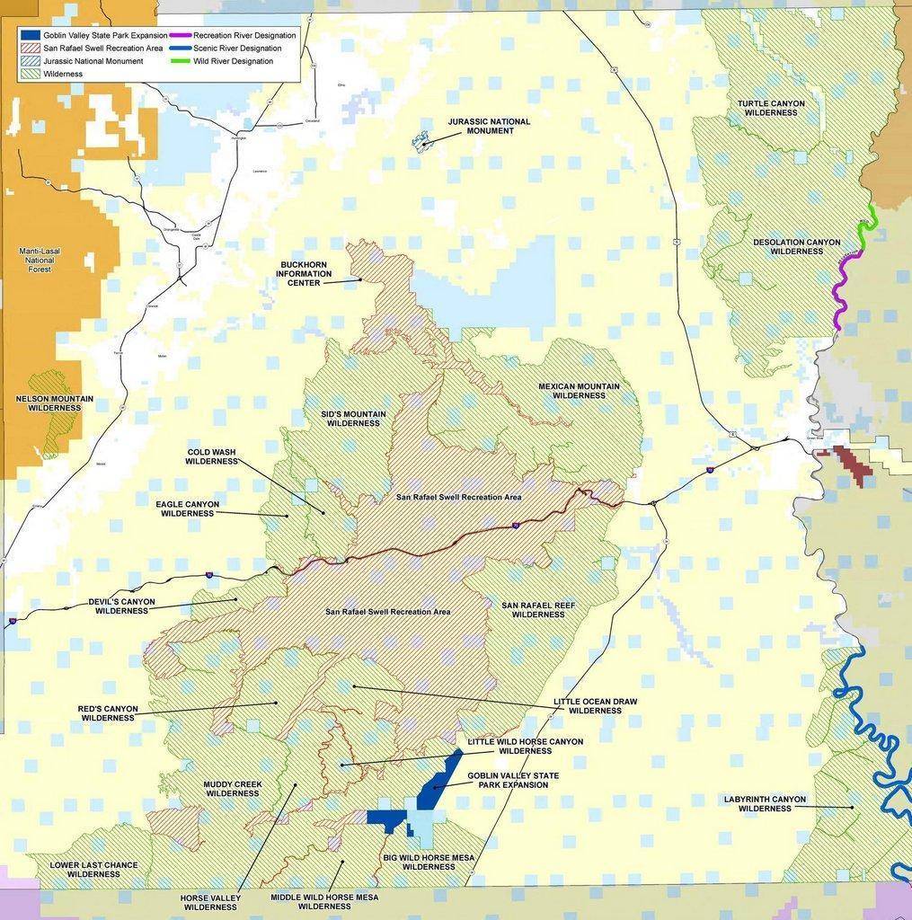
The above map shows the wilderness and recreational areas of Emery County as designated by the public lands legislation called the Dingell Act, which was enacted on March 12, 2019. The act was controversial when presented, and many have questioned how it will affect Emery County as implementation moves forward.
“The John D. Dingell, Jr. Conservation, Management, and Recreation Act consists of more than 100 individual bills that were introduced by 50 Senators and several House members, including Utah’s Emery County Public Lands Management Act,” the Bureau of Land Management (BLM) shared.
According to the BLM, the Dingell Act includes provisions impacting public lands nationally, including the permanent authorization of the Land and Water Conservation Fund, the Every Kid Outdoors Program and improvements to public land access.
The green striped area is wilderness and there are 17 BLM-managed wilderness areas in Emery County. The following wilderness areas were congressionally designated around the San Rafael Swell Recreation Area as part of the act: Big Wild Horse Mesa, Cold Wash, Devil’s Canyon, Eagle Canyon, Horse Valley, Little Ocean Draw, Little Wild Horse Canyon, Lower Last Chance, Mexican Mountain, Middle Wild Horse Mesa, Muddy Creek, Red’s Canyon, San Rafael Reef and Sid’s Mountain.
There is also one United States Forest Service managed wilderness area. Wilderness areas are closed to motorized travel, but are open to the public for non-motorized travel on foot or on horse.
The red striped area is a recreation area that allows motorized travel on designated routes and roads. This is known as the San Rafael Swell Recreation Area and is approximately 217,000 acres. It is also open to foot and horse travel, and more.
“The San Rafael Swell Recreation Area features magnificent badlands of brightly colored and wildly eroded sandstone formations, deep canyons, and giant plates of stone tilted upright through massive geologic upheaval,” the BLM shared. “The ‘Swell’ features endless amounts of recreational experiences, including off-highway vehicle riding, hiking, biking, horseback riding, canyoneering and river running.”
The light blue squares are Utah School and Institutional Trust Lands Administration areas and can be traded out for other blocks of land. The dark blue portion is Goblin Valley State Park.
The purple river is designated recreational, while the blue is scenic river and the green portion of the river is designated wild. The Jurassic National Monument (the blue striped area) is managed by the BLM.
“BLM Utah has been actively involved in implementation of the law,” the bureau shared. “BLM Utah looks forward to working with local communities, counties and the State of Utah to implement the new land designations, which help protect recreation opportunities and access on public lands, and helps to consolidate federal and state lands.”
For more information on the act and how it will impact Emery County, please click here. An interactive map can be found by clicking here.